In recent years, there has been a significant advancement in the field of Artificial Intelligence (AI) and Augmented Reality (AR). These technologies have become increasingly popular and have the potential to enhance virtual experiences in various fields such as gaming, education, healthcare, and...
A Program Reconstructs Ancient Maps from Travelers' Written Descriptions
18
29.06.2026
For centuries, historians and archaeologists have grappled with the fragmented nature of our past. Many ancient civilizations did not leave behind comprehensive cartographic records, or if they did, those maps have long since crumbled into dust. Instead, our geographical knowledge of historical trade routes, lost cities, and ancient empires is often trapped within the prose of travelers' journals, military logs, and literary epics. Deciphering these subjective, often poetic descriptions into accurate geographical data has traditionally been an exhausting, manual task prone to human error and bias.
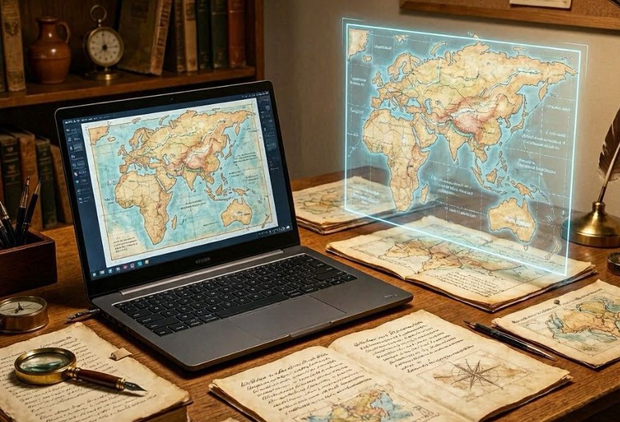
Today, the field of historical cartography is witnessing a technological renaissance. Researchers have developed sophisticated software capable of "reading" ancient texts, extracting geographic markers, and reconstructing complex, scalable maps from nothing but written descriptions. By bridging the gap between linguistics and geography, these programs are allowing us to visualize the world as it was seen through the eyes of the ancients.
The Methodology: Turning Prose into Points
The reconstruction process is a multi-disciplinary effort that utilizes Natural Language Processing (NLP) and Geographic Information Systems (GIS) to transform abstract narratives into concrete spatial data. The algorithm follows a rigorous multi-stage workflow to ensure accuracy.
1. Named Entity Recognition (NER) and Spatial Extraction
The program begins by scanning thousands of pages of historical manuscripts. Using custom-trained NLP models, the software identifies "geospatial entities"—place names, landmarks, and geographical features like rivers, mountain passes, or coastal cliffs. The AI is trained to understand archaic vocabulary, recognizing that "the river of silver" in an ancient manuscript might refer to a specific, identifiable waterway based on its context within the surrounding landscape.
2. Relative Positioning and Toponymic Linking
Because travelers rarely used modern coordinates, they relied on relative positioning: "three days' journey north of the great temple" or "beyond the range where the sun sets behind the peaks." The algorithm creates a mathematical graph of these connections. By aggregating these relative distances and directions from hundreds of different sources, the software triangulates the most probable location of a site. If one traveler says City A is two days west of City B, and another confirms City B is a day south of City C, the program weaves these fragments into a coherent spatial network.

Overcoming Subjectivity and Bias
The primary challenge in mapping historical texts is the subjective nature of human perception. A traveler's "day of travel" could vary significantly depending on the terrain or the speed of their caravan. The program addresses this by applying probabilistic modeling.
Statistical Normalization
The software assigns "confidence scores" to every description. It weighs information from official military logs—which tend to be precise about distances—more heavily than the hyperbolic descriptions found in epic poetry or folklore. By statistically normalizing these disparate accounts, the program filters out the "noise" and exaggeration, leaving a core of geographically consistent data points.
Reconciling Conflicting Accounts
- Conflict Resolution: If two manuscripts offer contradictory locations, the AI analyzes the temporal and cultural context of each source to determine which is more likely to be accurate.
- Toponymic Evolution: The program maintains a database of place-name evolution, understanding how names changed across centuries and languages to link modern geographic realities to ancient mentions.
Implications for Archaeology and History
The ability to automatically reconstruct maps has profound implications for archaeology. Researchers can now input the journals of a long-dead explorer into the software and receive a map showing exactly where they might search for an unexcavated settlement. This "algorithmic exploration" has already led to the discovery of hidden ruins that had been obscured for centuries, not by earth, but by the sheer difficulty of interpreting the written records left by our predecessors.
Conclusion: A New Lens on the Past
The marriage of computational linguistics and cartography is changing our fundamental understanding of human history. We are no longer limited by the physical maps that survived the ravages of time; we now have the tools to synthesize the entire record of human travel into a living, visual database. As these algorithms become more refined, they will continue to populate the "blank spaces" on our historical maps, turning the subjective words of ancient travelers into the objective geography of our shared heritage.